Going all the way to the end of the road (2/2)
This is the second part of “Going all the way to the end of the road”. In the first part we were following the dirt road, got stuck in a third river but made it to the other side and found a house with the inhabitants gone. We drove a bit further climbing up a hill where we got an unobstructed view and could see this:
<div style="text-align:center;">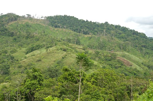 </div>
There were two more houses. Here is a zoomed picture of the first one:
<div style="text-align:center;">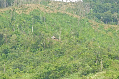 </div>
And here is the second one:
<div style="text-align:center;"> </div>
We didn’t try to find a way to get to these houses. It’s likely that there is none. There will be a trail but nothing wide enough for the Jeep. These people don’t have cars of any kind and the dirt road was probably only build so that a 4WD ambulance and of course the owners of these farms can get there. Peons walk or are allowed to use a horse. That’s the sad reality in these places.
We followed the road a bit further and came to a place with another great view. You should click on the image which takes you to Flickr. There view the picture in high resolution. It’s available as a 4288 x 2848 pixel image. That allows you to spot the houses. This looks like a small village. Unfortunately the road ended shortly after this point and turned into a narrow trail. There weren’t any obstacles on both sides of that trail. So maybe we would have been able to drive the Jeep all the way to these houses but then we just wanted to know where the road ends and it was already late afternoon. We decided it was time to head back. It’s usually not a good idea to stay too long. Rain is common in the late afternoon and even if it doesn’t look like it will rain we are in the rainy season and that means it should rain frequently. As we had trouble crossing the third river we thought better not to take changes.
<div style="text-align:center;"> </div>
Still we did have a look around. The following pictures show how it looks like after the forest has been cleared. That has been rainforest. Dependent whether there is a way to get the wood out trees with commercially interesting wood are felled and the rest burned. Or they burn it all. Then pasture get seeded and the burned stumps keep telling the story of the devastation that happened a while ago.
<div style="text-align:center;">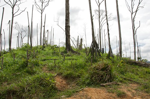 </div>
The Panamanian Ministry for Agriculture (MIDA) has published papers about the issue. They state that the conventional methods for cattle farming are not suited for the tropics. Destroying the forest will reduce the water supply and in the end lead to erosion and dry land. This has happened in the Azuera peninsula where for centuries pasture has been gained by completely burning the forest. Today there are bald hilltops with hardly any soil left.
<div style="text-align:center;">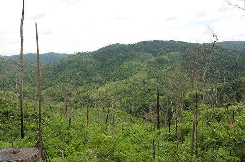 </div>
With the exception of the indigenous people from the Kuna tribe most of the people who live in this part of Panama came years ago from the town of Las Tablas in the Azuera peninsula. They could not find work nor land there and when work on the Bayano reservoir started in the 1970s they came to work on the dam and sought land in the region. There they started to do in the rainforest what their fathers did in the Azuera region before them.
<div style="text-align:center;">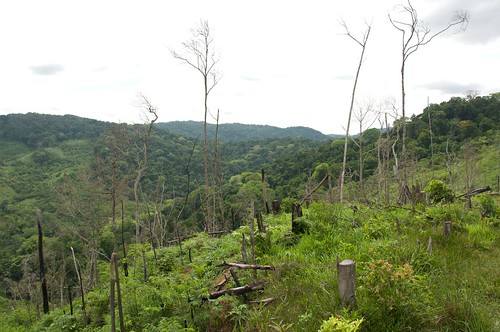 </div>
As an interesting tidbit let me tell you than in Spanish a cattle farmer is called ganadero. Cattle is ganado. The Spanish word for earning is ganar. It’s probably not a coincidence that both words are derived from the Spanish translation of the verb to earn …
| Previous | 10 Sep 2009 | Next |


About me
Hello! My name is Stephan Schwab.

I build and rescue software, and I write fiction about the human side of how it gets made. Here you’ll find my stories and novelas, notes on craft, and field notes from a life lived across several worlds.
Working with software teams is what I do professionally — see how on caimito.net. You can also read about my experience since 1986.